
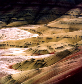
Painted Hills
The Painted Hills Unit includes these eroded remnants of the lower John Day Formation. These hills are largely composed of claystone, much of which is decomposed volcanic ash which periodically showered down on the area over millions of years and reaching a depth of over 1,000 feet (300 meters). In this image, you can see how the whole sequence as been slightly folded subsequent to its deposition.
Print No. A01NW-6-5
Painted Hills Close-Up
In this telephoto shot of the view above, the intricate layering in the claystone can be seen in the bands of color that are caused by various oxides of metals. In particular, the black oxides (probably manganese) occur in pockets along specific strata. Where they are exposed at the surface, rainwater has caused the oxides to "bleed" downslope, resulting in the patterns in this image.
Print No. A01NW-6-8

Painted Hills East View
Taken from the Painted Hill Overlook Trail, this is the view across Bridge Creek to Sutton Mountain. Sutton Mountain is capped by the 16 million year old Picture Gorge Flood Basalts (see below).
Print No. A01NW-6-6
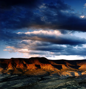
Carroll Rim Trail Sunset
This is the view from the top of the Carroll Rim Trail at the Painted Hills Unit, looking northeast at Sutton Mountain in the last light of day.
Print No. A01NW-7-12

Picture Gorge
Picture Gorge was created as the John Day River eroded a narrow slot through the 16 million year old Picture Gorge Basalt. The Picture Gorge Basalt was a series of lava flows associated with the Columbia River flood basalts that covered much of western Oregon and Washington at that time.
Print No. A01NW-5-3

Palisades and Arch
The Clarno Palisades (Clarno Unit) are composed of a succession of lahars that inundated a forested landscape. The arch in this image is a naturally-occurring erosional feature as surface drainage eroding through weaknesses in the formation undercut a section of the edge of the cliff. Also notable in the Clarno Unit are logs of petrified wood.
Print No. A01NW-7-1

Sheep Rock Overlook
Looking southeast from Sheep Rock Overlook is Sheep Rock. The rock is capped by a resistant knob of the Picture Gorge Basalt. Below are 25 million year old John Day Formation beds of volcanic ash weathered to claystone.
Print No. A01NW-5-11

Blue Basin
This is the view from the end of the Island of Time Trail in Blue Basin, named for the blue-green claystones. These claystones are the decomposed remnants of volcanic ash in the John Day Formation and have produced many fine fossil specimens.
Print No. A01NW-6-4
