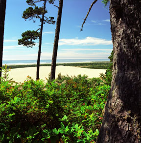
Oregon Dunes
The sedimentary rocks of the Coast Mountain Range of Oregon were uplifted between 30 and 45 million years ago, exposing them to the forces of erosion. River systems carried the sediment to the ocean where the actions of wind and waves have built up the sand dunes at Oregon Dunes National Recreation Area.
Print No. A99NW-5-6

Multnomah Falls
On the sheer southern cliffs along the Columbia River Gorge, Multnomah Falls is 2-tiered, dropping a total of 620 feet (190 meters). That makes it the fourth highest waterfall in the United States. Five flows of Yakama Basalt are exposed in the fall's cliff face. Approximately 300 basalt flows erupted about 6 to 17.5 million years ago (during the Miocene Epoch) and covered around 60,000 square miles (164,000 Km2) over three states. The flows are up to 16,400 feet (5,000 meters) thick!
Print No. A99NW-17-6

Above Wahkeena Falls
Wahkeena Falls is also along the scenic highway on the southern (Oregon) side of the Columbia River Gorge. Wahkeena is a Yakama Tribe word meaning "most beautiful".
Print No. A99NW-16-2
More Images of Waterfalls

Darlingtonia Bog
The collision of ocean crust into the continent resulted in slivers of rare rock types, called ultramafic, to surface in a few localities in the Klamath Ranges. These rock types are unstable at the surface, weathering to a red iron-rich soil. Where ample water abounds, this soil in turn can be host to rare species of plants. In a few bogs, this one called darlingtonia (a.k.a. cobra or pitcher plant) is unique. It is carnivorous, trapping insects lured into the plant by an insect-attracting odor. Once trapped, the insects are slowly dissolved, supplying nutrition to the plant. A true example of deadly beauty. Here's a closer look
Print No. A99NW-4-12

Abert Rim
Named after Colonel J.J. Abert, the Abert Rim is a plateau in south-central Oregon that drops 2,500 feet (760 meters) to Lake Abert along one of the highest fault scarps in the United States. This north-south trending tensional fault is a dramatic example of the much more extensive Basin and Range geomorphology that spans from parts of eastern California across most of Nevada. The rim is capped by the Steens Basalt, a flood basalt deposited over the last 10 million years.
Print No. A01NW-2-7

Silver Point, Arcadia Beach
View south from Silver Point along the Arcadia Beach coastline in northern Oregon. This photo was taken at dusk as a Pacific storm was approaching the Pacific Northwest.
Print No. A99NW-5-9
