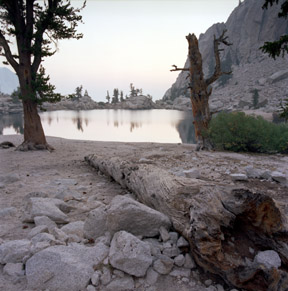
Lone Pine Lake
Approximately 2.8 miles (4.5 Km) from the trailhead, Lone Pine Lake is one of the first views in the early dawn light. Looking east from an elevation of 9,420 feet (2,871 meters), the haze of the McNally Fire is apparent in the distant Owens Valley.
Print No. A02-31-11

Whitney Massif Sunrise
The first sunlight hits the steep granitic face of the Whitney Massif upon the approach of the meadow at Bighorn Sheep Park just before Outpost Camp. Mount Whitney is hidden behind Pinnacle Ridge on the right. Wotans Throne is the blocky mountain bathed in the morning sun just left of center.
Print No. A02-31-12

Trailside Meadow
At a distance of approximately 5.3 miles (8.5 Km) from the trailhead, Trailside Meadow (also known as Ram Horn Park) is a popular watering hole for hikers.
Print No. A02-32-2

Whitney Massif
This was taken from an unnamed lake at Trail Camp at an elevation of 12,039 feet (3,669.5 meters), and approximately 6.3 miles (10.1 Km) from the trailhead. Mount Whitney, the highest point in the Sierra Nevada and the rest of the contiguous 48 states, is first seen from just beyond this lake. In this image, Mount Whitney is to the right, just out of sight, along the distant ridgeline. This is an important watering hole for hikers making the ascent to the top. It is also inhabited by rather aggressive marmots.
Print No. A02-32-4

Trail Crest and the Needles
After ascending 97 switchbacks over 2.2 miles (3.5 Km) and gaining 1,738 feet (530 meters) in elevation from Trail Camp, the trail reaches a notch in the crest of the Whitney Massif. Looking north from this spot, Mount Whitney is hidden behind the Needles and Mount Muir (on the right).
Print No. A02-32-6

Trail Crest View
Also taken from Trail Crest, this is the view towards the west, looking into Sequoia-Kings Canyon National Park. Hitchcock and Guitar Lakes lie at the base of the western slope of Mount Whitney. The impressive massif in the upper left corner is Mount Hitchcock. In the distance is the north-south oriented Kern Canyon.
Print No. A02-32-8

Summit View
This is the view looking southeast from the 14,494-foot (4,418-meter) peak of Mount Whitney. The prevalent blocky weathering of the Whitney Granodiorite is a product of exfoliation. The smoke from the McNally Fire obscured the distant view, but provided some additional depth perspective. In the shadows are the Needles and Pinnacle Ridge. The "small hill" behind the largest lake in this view is Wotans Throne!
Print No. A02-33-3
97 Switchbacks
Beginning the descent from Trail Crest down the 97 switchbacks section of the Mount Whitney Trail, this is the view looking northeast from the 9th switchback from the top. The unnamed lake at Trail Camp is seen in the right-center of the image. Here is a closer look at the switchbacks in this image.
Print No. A02-33-11

Whitney Massif from the 97 Switchbacks
Just beyond the 68th switchback from the top of the 97 switchbacks section of the Mount Whitney Trail, this is looking back to the north at the Whitney Massif. Mount Whitney is the broader peak with a flat top in the background.
Print No. A02-33-12

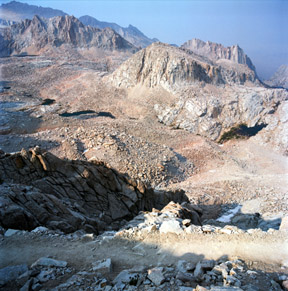
Consultation Lake
Just southwest of Trail Camp is Consultation Lake. Looking south across the lake is Mount McAdie at an elevation of 13,537 feet (4,207 meters) on the right and the saddle to Mount Irvine left of the image.
Print No. A02-34-2
