
Sierra Crest
This is the view, looking north, across the rugged, glacially-carved divide of the Sierra Nevada. The pointed mountain just right of center is University Peak, which lies on the eastern border of Kings Canyon-Sequoia National Park. Mount Whitney lies about 10 miles (16 km) to the southeast of this peak. Owens Valley is in the distance. This photo was taken from about 30,000 feet on a Southwest Airline 737 at sunset. Look closely and you can see sun rays from the peak shadows passing over the valley.
Print No. A00-26-7
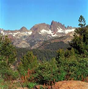
The Minaret
Taken from Minaret Vista Point, the Minaret is located along the east front of the Sierra Nevada, west of Mammoth Mountain and the Long Valley Caldera. Including Mount Ritter at 13,157 feet (4,011 meters) and Banner Peak at 12,945 feet (3,947 meters), the main peaks of the Ritter Range, this area is preserved in the Ansel Adams Wilderness. The jagged glaciated peaks include the volcanic and volcaniclastic rocks from the Cretaceous-age Minarets Caldera.
Print No. A99-34-3

Solar Column - Sierra Foothills
Reflections off ice crystals in distant cirrus clouds creates a vertical column above the setting Sun in this image taken from Jackson, California, along the famous gold-rush era Highway 49.
Print No. B96-19
More images of sun rays

Lake Tahoe from 30,000 Feet
Taken from a Southwest Air 737, this view looks north across the lake. The mountain in the lower right corner is Heavenly Valley Ski Resort.
Print No. A99-40-5
More images of Lake Tahoe
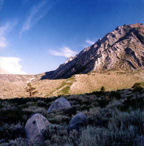
Faulted Moraine
A clear indication of neotectonic activity, this vertical offset in a Pleistocene-age lateral moraine shows the recent activity (less than 12,000 years) of the Hilton Creek Fault along the eastern boundary of the Sierra Nevada. Located along the entrance to McGee Canyon, the moraine exhibits about 65 to 80 feet (20 to 25 meters) of offset, downward to the east. The scarp is visible as the green vegetation on the ridgeline, just above the shadow, sloping 45o down to the left.
Print No. A02-28-7

Sevehah Cliff and Convict Lake
This is an early morning view looking west at the Sevehah Cliff rising above Convict Lake along the steep eastern side of the Sierra Nevada. The Sevehah Cliff is composed of beds of Devonian-age Mount Morrison Sandstone, which are steeply-dipping to the east. However, these beds are overturned, as they were tilted westward over 90 degrees during a long history of folding and faulting, beginning with the Late Devonian-Early Mississippian Antler Orogeny. This view is along the path to the top of Mount Morrison. These geologic units pre-date the granitic intrusions that make up much of the high Sierras. They are typically found as roof pendants, capping the tops of ridges along some portions of the eastern Sierras. Here is a close-up of the bedding in the cliff face.
Print No. A02-24-2
This is one of the views along the trip to Mount Morrison

Whitney Massif
This was taken from an unnamed lake at Trail Camp, along the main trail from Whitney Portal to the top of Mount Whitney. Mount Whitney, at 14,494 feet (4,418 meters), is the highest peak in the contiguous 48 states. The massif is a steep cliff of Cretaceous-age granodiorite and granite. The east side (shown here) is particularly steep, as is much of the eastern portion of the Sierra Nevada, due to normal faulting at the boundary with the Basin and Range Geomorphic Province. In this image, Mount Whitney is to the right, just out of sight, along the distant ridgeline.
Print No. A02-32-4
This is one of the views along the trip to Mount Whitney
