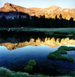
Mount Dana from Tioga Pass
Looking east with Dana Meadows in the foreground, Mount Dana is the peak on the right. The peak on the left, which appears from this perspective to be higher, is the northwest shoulder of Mount Dana. The climb to the top of this shoulder is less than half of the climb to the peak. This image was taken at sunset after the climb to the peak.
Print No. A02-22-11
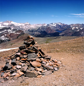
Rock Cairn on the Shoulder
At approximately the 12,000-foot elevation, the trail reaches a bench. The view is still blocked to the east by a slight rise, but the summit now is in full view. This bench, and perhaps the last clear indication of a single trail to the top, is marked by a 4- to 5-foot high rock cairn, a typical trail marker that may gradually increase in size thanks to passing hikers. Here is a close-up of the cairn and its current occupant. the northwest point of the shoulder (from the image above) is the first bump just above and to the left of the top of the cairn. In the background is Saddlebag Lake to the north. Mount Conness, which also marks the Yosemite National Park border, is the high peak on the far left.
Print No. A02-21-9
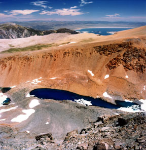
Dana Lake and Mono Lake
Looking northeast over the narrow edge leading northwest from the peak, Dana Lake lies within the secluded Glacier Valley, named for the glaciers on the northeast side of Mount Dana (next image). The vivid colors of the lake are either due to rock flour, scoured by the glaciers, or ice somehow stuck on the bottom of the lake, reflecting the sky. Behind the valley is Dana Plateau, an erosional surface. Lee Vining Peak, Mono Dome, and Mono Lake are left to right in the background.
Print No. A02-22-1
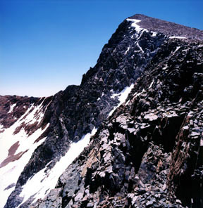
Mount Dana Summit
From the same position as above, this is the view to the south. Here is the peak of Mount Dana, with its steep northeastern wall and the top of its glaciers. The final ascent is a scramble along the slope on the right
Print No. A02-21-12

Mono Lake from the Summit
Looking northeast from the 13,053-foot (3,979-meter) summit provides a truly unique view of Mono Lake from across the Ansel Adams Wilderness.
Print No. A02-22-4
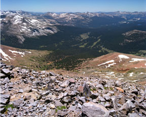
Tuolumne View
Looking back to the west from the peak, the south end of Dana Meadows at the foot of the hillside extends into the distance and becomes Tuolumne Meadows. The high peaks along the south side of Tuolumne Meadows dominate the skyline. The horns of Unicorn Peak are just right of center. On really clear days like this one, the Coast Ranges, over 130 miles (210 Km) away, are barely visible from the peak in this close-up.
Print No. A02-22-7
