
Vogelsang Peak - Vogelsang High Sierra Camp
At an elevation of 10,180 feet (3,103 meters), Vogelsang is the highest of the High Sierra Camps. Rising substantially above it is Vogelsang Peak at 11,516 feet (3,510 meters). Vogelsang Peak is a glacially-sculpted aręte and part of the Cathedral Range. Vogelsang was established as a High Sierra Camp in 1924.
Print No. A03-27-3

Merced Lake - Merced Lake High Sierra Camp
Merced Lake, at an elevation of 7,230 feet (2,204 meters), is the lowest of the High Sierra Camps. It lies in the upper stretches of Little Yosemite Valley. Merced Lake was one of the original High Sierra Camps, established in 1916. From this view, looking west, you can see a rare perspective of the backside of Half Dome in the distance.
Print No. A03-28-8

Clark Range Sunset - Sunrise High Sierra Camp
Sunrise High Sierra Camp, at an elevation of 9,350 feet (2,850 meters), lies at the edge of Long Meadow, seen in the foreground. In this south-facing view, the Clark Range rises above Little Yosemite Valley, capped by the aręte of Mount Clark at 11,522 feet (3,512 meters). Sunrise is the youngest of the High Sierra Camps, established in 1961.
Print No. A03-29-4
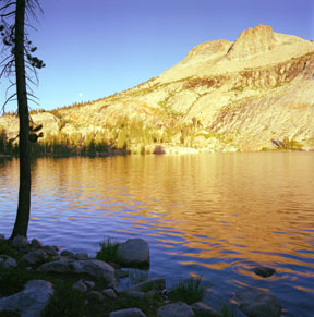
May Lake and Mount Hoffmann - May Lake High Sierra Camp
Lying on an edge of the east side of Mount Hoffmann is May Lake High Sierra Camp at an elevation of 9,320 feet (2,841 meters). May Lake was named for the wife of Charles Hoffmann, topographer for the State Geological Survey and member of the 1863 Whitney Survey. May Lake was established as a High Sierra Camp in 1938. Here is another view of Mount Hoffmann from the lake.
Print No. A03-31-12

California Falls
California Falls is located along the Tuolumne River, less than 2 miles downstream of the Glen Aulin High Sierra Camp, and about 7 miles from Tuolumne Meadows. California Falls is the first of a sequence of cascades as the Tuolumne River enters the "Grand Canyon of the Tuolumne".
Print No. A03-32-9
More Images of Waterfalls in Yosemite

Cirrus over Glen Aulin - Glen Aulin High Sierra Camp
The White Cascade, named by the Whitney Survey in 1866, is part of the Tuolumne River. At the base of the cascade is the Glen Aulin High Sierra Camp at an elevation of 7,850 feet (2,393 meters). Glen Aulin, which means beautiful valley or glen, was established as a High Sierra Camp in 1927. Cirrus are wispy clouds composed of ice crystals, which form at about 20,000 to 40,000 feet (6,000 to 12,000 meters) above the ground.
Print No. A03-33-10

Grand Canyon of the Tuolumne - Glen Aulin High Sierra Camp
In this sunset view just outside of the Glen Aulin High Sierra Camp, the Tuolumne River descends over 4,000 feet (1,200 meters) over about 25 miles (40 Km) along the river and 39 miles (63 Km) by trail to the Hetch Hetchy Reservoir. At one point during the Pleistocene ice ages, a glacier much larger than the one that buried Yosemite Valley carved through this valley, burying it under as much as 4,000 feet (1,200 meters) of ice. The glacier also formed the u-shaped valley at Wildcat Point, the prominant cliff face near the center of the image.
Print No. A03-33-11
