
Soda Springs, Tuolumne Meadows
Forced back to the surface by the pressure of groundwater seeping into the higher granitic peaks, these springs casually bubble out onto the Tuolumne Meadows and get their name from the mineralized water which is mildly carbonated.
Print No. A98-37-9
Here is a close-up of the bubbling action in this photo
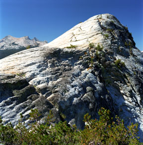
Lembert Dome
Lembert Dome rises above the east side of Tuolumne Meadows. It is a classic granodiorite dome, carved by glacial activity. The arętes of Unicorn Peak are seen in the distance, across Tuolumne Meadows.
Print No. A02-36-3
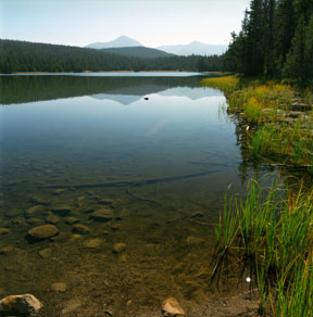
Dog Lake
Dog Lake is located in the northeast portion of Tuolumne Meadows, just north of Lembert Dome. Looking east from here, the high point in the distance is Mount Dana at 13,053 feet (3,979 meters), the second highest peak in Yosemite National Park.
Print No. A02-36-1

Elizabeth Lake Reflection
Elizabeth Lake is an alpine lake and lies just south of Tuolumne Meadows. The arętes of Unicorn Peak in the Cathedral Range are reflected in the lake shortly after sunrise.
Print No. A02-23-9
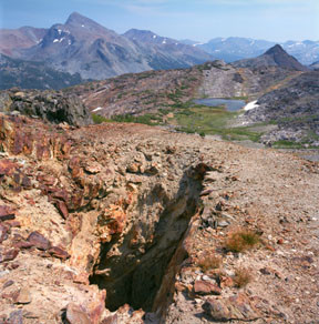
Loch and Lode
Northeast of Tuolumne Meadows, and just west of Tioga Pass, the granitic rocks which dominate most of Yosemite National Park give way to older overlying metasedimentary and metavolcanic rocks. As the granitic magma intruded into the overlying rocks, chemical reactions resulted in the deposition of various minerals, most notably precious metals. Along this contact, mine shafts were excavated looking for silver. The Great Sierra Mine site is located along the top of the ridgeline behind the lake. Some of the mine shafts are still present, as are the remnants of a few stone buildings from the city of Dana. Gaylor Peak is just right of center. The pointy peak on the left is Mount Dana, on the east side of Tioga Pass.
Print No. A02-31-5

Granite Lakes
Just southwest of the Great Sierra Mine are the Granite Lakes, two lakes formed within a glacial cirque. The peak with the most snow in front of it (just right of center) is Mount Lyell. At 13,114 feet (3,997 meters) it is the highest peak in Yosemite National Park.
Print No. A02-31-7
