
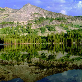
Cathedral Peak and Cathedral Lake
The scenic glacial aręte of Cathedral Peak is reflected in Lower Cathedral Lake. Cathedral Peak, at an elevation of 10,911 feet (3,326 meters), is one of the most spectacular points in the Tuolumne Meadows vicinity.
Print No. A02-21-4

Cascade from Cathedral Lake
Spilling over a narrow embankment from Lower Cathedral Lake towards Tenaya Lake, the water here runs briskly over a wide swath of granodiorite, eroding mainly along the spalling exfoliation planes.
Print No. A02-20-3

Glacial Polish and Zoned Feldspar
On the steep slope west of Lower Cathedral Lake (shown above), evidence of Pleistocene glaciation can be seen in the polished surface of the granodiorite. Also in the bedrock surface, the granodiorite here is porphyritic, with huge well-formed zoned feldspar crystals. The zoning is caused by changes in composition as the magma cooled during the crystal formation.
Print No. A02-20-5
Here is a close-up of a zoned feldspar crystal in this image.

Evidence of Glaciation
Visible in this view from above Olmsted Point are three pieces of evidence that this area was glaciated during the Pleistocene ice ages. First, there are glacial striations, parallel grooves carved into the polished granite by large blocks pushed by the glacial ice. You can see patches of the smooth polished surfaces. Second, the large out-of-place blocks resting on the high perches in the distance are known as glacial erratics (particularly if they consist of a rock type that isn't like the bedrock upon which they lie). Third, in the background you can see the famous Half Dome which itself was carved by the glaciers originating from these highlands.
Print No. A99-36-8
Tenaya Lake Reflection
Early Native Americans living in Yosemite called this "Pyweak", the Lake of Shining Rocks. The first white explorers named it Tenaya, after the tribe's legendary chief.
Print No. A98-37-10

Little Devils Postpile
West of Tuolumne Meadows along the Pacific Crest Trail, near Glen Aulin, this isolated outcrop of columnar basalt lies along the Tuolumne River. This is the remnant of a small volcano that erupted about 9.4 million years ago. The formation of columnar basalt is described with an image from the much larger Devils Postpile near Long Valley Caldera, southeast of Yosemite National Park.
Print No. A02-37-1

Mount Hoffmann from May Lake
Mount Hoffmann, at an elevation of 10,850 feet (3,307 meters) is due west of Tuolumne Meadows and is the geographic center of Yosemite National Park. It was named after Charles Hoffmann, topographer for the State Geological Survey and member of the 1863 Whitney Survey. Along its eastern base is May Lake, which is the location of one of the High Sierra Camps. Around May Lake are older metamorphic rocks, including quartzite, marble, and calc-silicates (somewhat of a mix between the other two) sandwiched between the Cretaceous-age Mount Hoffmann and Half Dome granodiorites.
Print No. A02-37-10
